Northern Ghana to the coast · The routes behind the castles
The Inland Slave Routes of Ghana
The dungeons at Cape Coast and Elmina were the last few hundred metres of a journey that began, for most people held in them, several hundred kilometres north. This is the road they walked, who controlled it, and why British abolition in 1874 did not close it.
A crossroads of two trades, not one
Almost everything written about slavery in Ghana treats it as a story about Europeans on the coast. That is half the map.
The savanna towns of what is now northern Ghana sat where two separate slaving networks crossed. One ran north, across the Sahara into North Africa and the Middle East, and had been running for many centuries before a European ship reached this coast. The other ran south to the Atlantic forts, from the sixteenth century onward.
Salaga served both. A captive taken in a raid near Paga could end up in Morocco or in Jamaica, and which one depended on which caravan bought them.
What was actually being traded
Kola nuts, above all. The northern trade ran on kola from the southern forest, moving north to Muslim West Africa where it was in permanent demand. Also gold, cowries, cattle, groundnuts, salt, cloth. People were one commodity among several, exchanged against kola and cowries, and that ordinariness is the most disturbing thing in the record.
Why the north supplied
Because it could be raided. The savanna states were decentralised and largely without cavalry or firearms, while their neighbours to the north and south had both. Raiding was not incidental to the trade — it was the production method.
Where the profit went
South and east, to the forest kingdoms and coastal states with access to European buyers, and north to the Sahelian polities. The regions that supplied the people kept almost none of it, and remain by every indicator the poorest parts of Ghana today.
And many never left Africa
A large proportion of those taken were absorbed into domestic slavery within West Africa — as farm labour, household labour, and in the armies of the states doing the raiding. The Atlantic was the most documented destination, not the only one.
The routes themselves
These were not paths so much as commercial corridors, and their shape was set by who controlled the ground. Four main routes ran from the northern territories down to Kumasi, including the corridor from Wa and Bole to the Asante capital and on to the coast.
From Kumasi and the central markets, the caravan routes ran to the sea:
- The central corridor — Kintampo, Kumasi and Techiman down to Cape Coast Castle and Elmina. The main artery, and the one most visitors are unknowingly tracing when they drive to the coast.
- The eastern corridor — down the Volta from Kete Krachi, and through Krobo, Akwamu and Anlo-Ewe country to Keta, Ada and Accra. The Danish end of the trade: Fort Prinzenstein at Keta, Fort Kongenstein at Ada Foah, Christiansborg at Osu.
- The western corridor — through Abron, Dormaa and Sefwi, developed largely to bypass Asante control.
- The northern feeders — from Pikworo and the raiding grounds of the far north and what is now Burkina Faso, roughly 150 kilometres south on foot to Salaga.
The map changed in 1874, and the reason is instructive. The British defeat of Asante in that year destroyed Kumasi's military dominance over the north. Provinces broke away, Asante control over the trade routes loosened — and new routes developed that went around Kumasi rather than through it: down the Volta in the east, and through Abron, Dormaa and Sefwi in the west. The newly independent authorities encouraged them, because of the revenue. Breaking Asante did not break the trade. It redistributed it.
The market towns
-
Pikworo
A holding and auction camp at the top of the country, three kilometres from the Paga crocodile ponds. Around two hundred people held at a time, in the open, eating from bowls they cut into the granite. From here, 150 kilometres south on foot to Salaga. Pikworo in full -
Salaga
Founded in the sixteenth century within the Gonja kingdom by the Mande leader Ndewura Jakpa, overrun by Asante forces in 1744, and one of the leading market centres in West Africa. Slaves were exchanged for kola, cowries and gold. The pond called Wonkan bawa — Hausa for the bathing place of slaves — and a baobab at the former market site are still there. Salaga in full -
Kintampo and Atebubu
Market towns that rose sharply after 1874, when the loosening of Asante control created demand for centres outside Kumasi's reach. Caravans ran Salaga to Kintampo, then south. Salaga and Kintampo were commercial rivals, and Salaga traders often routed to Kete Krachi rather than deal with Kintampo at all. -
Kete Krachi
The river waypoint that took over much of Salaga's traffic, moving captives south by canoe down the Volta. Riverside villages along the route, Nkonya Tepo among them, were themselves raided for people because of their access to the water. -
Assin Manso
The final holding point before the castles, on the Nnonkonsuo — the Slave River — where captives were washed before being taken to the coast for sale. For a great many people, the last time they touched fresh water in Africa. Assin Manso in full -
Cape Coast, Elmina, Keta, Ada, Osu
The end of the inland road and the start of the sea one. British, Dutch, Portuguese and Danish, strung along a few hundred kilometres of shore — the densest concentration of European trading fortifications anywhere in the world.
Who ran it
Europeans rarely went inland. They did not need to. The capture, the marching, the holding and the selling were carried out by African polities and merchants, and the Europeans waited on the coast with goods to exchange.
This is not a revisionist point and it reduces European responsibility by precisely nothing. Atlantic demand created the market. The ships, the capital, the insurance and the plantations were European, and the scale was set in Europe. But the supply chain ran on African capture and African sale, and the states at the top of it grew powerful on the proceeds.
Asante
A major supplier, moving war captives and enslaved people through Salaga and south to the coast. Asante's expansion and its military strength were bound up with the trade, and it controlled the central corridor until 1874.
Gonja and the northern states
Salaga lay in Gonja territory and its market was the northern hinge of the whole system. The northern kingdoms were both raiders and raided, depending on the decade and the neighbour.
The Zarma raiders
In the late nineteenth century, mounted and armed raiders under Babatu and others moved through the Gurunsi lands taking captives on a scale that emptied villages. Pikworo exists because of raiding of this kind. The collective name outsiders still use for those peoples — Gurunsi — was Babatu's own coinage.
The middlemen
By 1884 Asante observers noted the trade shifting from Salaga to Krakye, Kpando, Kpong and Accra — which historians read not as decline but as the multiplication of intermediaries along an expanding axis. More markets meant more people taking a cut, not fewer people being sold.
What abolition did not do
This is the part of the story that almost never reaches a visitor, and it is the most important thing on this page.
Britain abolished the slave trade in 1807 and abolished slavery in the Gold Coast Colony in 1874–75, following the defeat of Asante. Every heritage itinerary treats that as the end.
It was not the end. It was a rerouting.
- 1884. Asante records the trade shifting to new markets — Krakye, Kpando, Kpong, Accra — a decade after abolition. Historians read the spread as the expansion of the Salaga trading axis and its middlemen, not its collapse.
- 1887–89. The British Commissioner resident at Salaga, Reginald Firminger, reports that around twenty thousand slaves were disposed of there annually — a figure he says he verified through numerous independent inquiries. Thirteen years after abolition, in a town with a British officer living in it.
- 1889. The German traveller L. Wolf reports that Salaga is no longer principally a kola market, and that the slave trade is being carried on energetically.
- 1890–95. George Ferguson is sent to secure treaties across the Northern Territories — Bole, Daboya, Yendi, Bimbilla, Wa, Gambaga.
- 1896. Basel missionaries visiting Krakye, Nkoranza and Atebubu record slave-trading in the district increasing. A man is being sold for around eight pounds. This is the year the trade is formally suppressed.
And the British motive was mixed, on their own record. The extension of control into Asante and the Northern Territories was undertaken partly to suppress slave raiding — and partly to secure free trade and make the colony viable, and partly to keep the French and Germans out. Britain had been long reluctant to expand north precisely because it meant expense with no material gain. Suppression happened where it coincided with interest.
So when you stand at Pikworo and a guide tells you the camp operated until the 1840s, hold that alongside a British officer at Salaga in 1888 counting twenty thousand people a year. The coast closed. The interior did not.
Following the route today
Almost every heritage itinerary sold to visitors begins at a castle. That is the last chapter. Run it in the order people actually walked it and it becomes a completely different experience.
- 1. Pikworo, Paga Nania — the holding camp at the top of the country. How to visit.
- 2. Sandema — Builsa country, and the Feok festival each December, which commemorates fighting the raiders off. The other side of the same history.
- 3. Gwollu and Nalerigu — the defence walls communities built to keep raiders out. What people did when nobody was going to protect them.
- 4. Salaga — the market, the bathing pond, the baobab.
- 5. Kete Krachi and the Volta — the river leg, and the villages raided along it.
- 6. Assin Manso — the last wash.
- 7. Cape Coast and Elmina — the door, and the sea.
It is a long journey and most people will not do all of it. But doing even the first and the last, in that order, changes what the castles mean. You arrive at the coast having already crossed the country the way the people held there did, and the dungeon stops being the beginning of the story.
What we can and cannot say
Numbers you will see that are wrong
Some sources put the transatlantic total at twenty-five to thirty million people. That is badly inflated. The documented figure, from the shipping records assembled over decades, is in the region of twelve and a half million embarked, with roughly ten and a half million surviving the crossing. The real number is appalling enough without inflation, and inflation hands critics an easy dismissal.
Numbers nobody has
How many people passed through Pikworo. How many died on the road to Salaga. How many of those sold at Salaga went north rather than south. These were not recorded, because the people being counted were cargo and the accounts that survive are commercial. Anyone giving you a confident total for the inland routes is estimating.
Dates that are traditions
Pikworo's commonly cited 1704 to 1845 appears everywhere without a source. Site histories across the north compress raiders, decades and resistances into single stories. We flag these where we find them rather than repeating them as record.
What is firm
The routes, the market towns, the commodities, the political control, and the post-abolition continuation are all documented in colonial correspondence, missionary records, traveller accounts and the historical literature. The bowls are cut into the rock at Pikworo. The pond at Salaga has its name.
Connected reading
- Why the roots lead inland — the coast was the exit, not the origin.
- Pikworo Slave Camp in full — where the northern route starts.
- Visiting Pikworo — how to get there and what the guide shows you.
- Salaga Slave Market — the northern hinge of the whole system.
- Assin Manso — the last wash before the coast.
- Forts and Castles of Ghana — where the inland road ends.
- The Kassena, and the Crocodiles — the people who were raided, and the name their raider gave them.
- Beyond the Pond — the northern circuit, sorted by distance.
- The History of Ghana — Gonja, Asante, the northern kingdoms and the road to 1957.
- Ghana-Net.com — the main portal. Publishing on Ghana since December 2000.
Practical details last verified . Route structure, market-town history and the post-abolition record draw on colonial correspondence, missionary reports, traveller accounts and the published historical literature, including the reports of District Commissioner Reginald Firminger resident at Salaga 1887–89, the observations of L. Wolf in 1889, Basel missionary accounts from Krakye, Nkoranza and Atebubu in 1896, and the George Ferguson treaty missions of 1890–95. Salaga's founding in the sixteenth-century Gonja kingdom by Ndewura Jakpa and its capture by Asante in 1744 are recorded in the standard histories. Transatlantic embarkation figures are those of the assembled slave-voyage databases. Site-specific dates in the north, including Pikworo's commonly cited operating dates, are received tradition and are identified as such. All photography © Remo Kurka. Usage strictly by prior authorisation only.
Long before the infamous dungeons of Cape Coast and Elmina became symbols of the transatlantic slave trade, the suffering began deep inland. Across Ghana’s northern and central regions, a network of inland slave routes connected remote villages, slave camps, and market towns to the coast — forming a hidden geography of captivity and commerce.
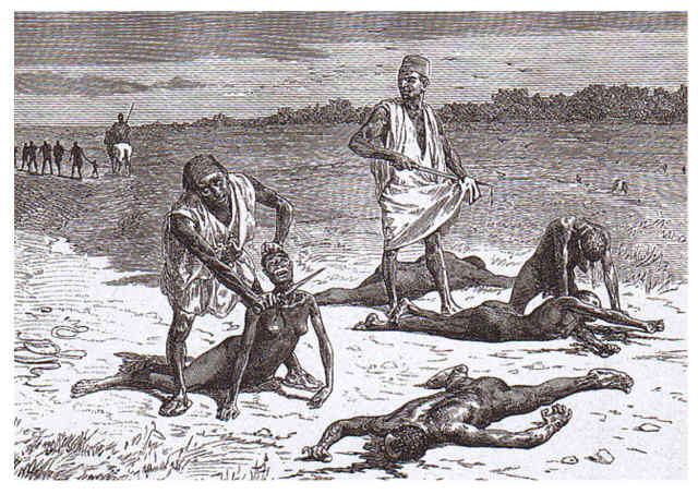
Not strong enough, to be sold? This is, what happened! This is work of African slave hunters!