In Ghana’s Upper East Region, the land speaks — Here, every step is a story,
and every encounter is a window into centuries of tradition.
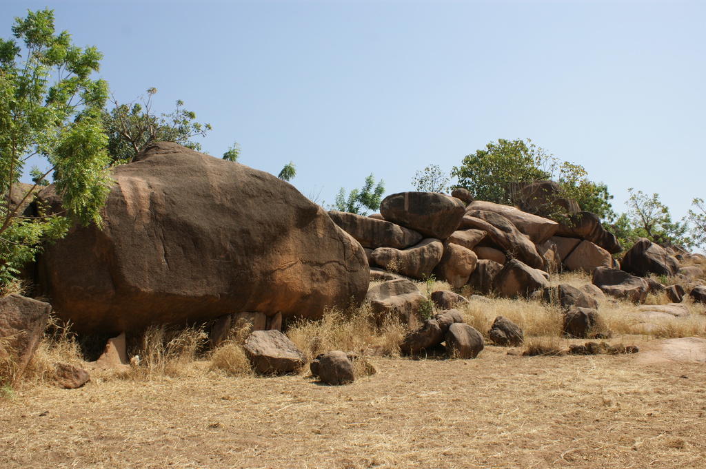
Upper East, Ghana, Rocks (c) Remo Kurka
Upper East Region · Paga and the Kassena villages · On foot
Savannah Walks & Village Tours
The half-day almost nobody books, and the one that changes what you understand about northern Ghana. What looks like scrubby bush with a few trees left in it is a farming system several centuries old — and knowing how to read it is the difference between a walk and a tour.
What the walk actually is
Two to three hours on foot, from Paga out through the surrounding Kassena villages and the farmland between them, with someone local who knows whose land you are crossing.
There is no trail, no visitor centre and no signage. There is a landscape that is entirely inhabited and entirely worked, and a guide who can tell you what you are looking at. That is the whole product, and it is better than it sounds.
Why it is worth doing
Because the crocodile pond takes half an hour and Pikworo takes an hour, and after that most visitors get back in the car having seen two attractions and no country. The walk is the only part of a Paga day where you are in the ordinary landscape rather than at a site.
How hard it is
Flat, and not physically demanding. The difficulty is entirely heat, which in this region is not a minor consideration. Early morning is not a preference here, it is the design of the day.
How to arrange it
Through the tourism office at the ponds, or through your accommodation in Bolgatanga or Navrongo. Not something to improvise by wandering off on your own — you would be walking through people's fields and compounds uninvited.
What it costs
Set locally and negotiable, and worth more than you will be asked. We do not publish figures. Pay properly and directly, and see the section below on why that matters here more than at a gated site.
Reading the landscape
Here is the thing that transforms the walk, and almost no guide will lead with it because to them it is simply obvious.
Those scattered trees standing in the middle of the fields were not missed by the clearing. They were kept.
This is a parkland agroforestry system: a deliberate arrangement in which economically useful trees are retained and protected while the ground beneath them is cultivated. It runs in a belt across the West African savanna and it has been managed this way for centuries. What reads to a European eye as degraded bush with a few survivors is a designed landscape.
The vegetation
Sudan and Guinea savanna: short, widely spaced, drought-resistant deciduous trees over a ground flora of grass, which burns off in the long dry season. Fire is part of the cycle here, both natural and set.
The soils, honestly
Upland soils developed on granite — shallow, coarse, low in organic matter and low in fertility, and declining. Bush fires, fragmentation, continuous cropping and overgrazing are all named in the agricultural record as degrading them further. The trees are part of what holds this system together.
One season, and it is erratic
Rain falls May to October, averaging around 950 mm, in a single unimodal season. There is no second chance in a bad year and no irrigation across most of this land. Everything you will walk past depends on those five months arriving as expected, which increasingly they do not.
The crops
Millet, sorghum, maize, rice, groundnuts, beans, sweet potato, leafy vegetables. Compound farming close to the houses, more extensive bush farming further out — the land nearest the village is the most intensively worked and generally belongs to the founding lineages.
The trees, and who they belong to
Four species dominate the parkland here, and each is retained for a reason.
- Shea — the most important. The nuts are collected, processed and sold; the butter goes into food, skin preparations and, increasingly, an export market. Agricultural officials in this region call it "the cocoa of the north," and they are not exaggerating its economic weight.
- Dawadawa — the African locust bean. The pods are fermented into the pungent dark seasoning that flavours a great deal of northern cooking. Ask to smell it being made if the chance comes up.
- Baobab — leaves for soup, fruit pulp for drinks, and the unmistakable shape that makes every photograph of this region recognisable.
- Acacia and others — fodder, fuel, shade, and nitrogen back into a soil that badly needs it.
Now the part that matters most, and that visitors almost never learn.
The trees are not the property of whoever farms the ground beneath them. Land in this system is held communally, and shea and other native trees are generally regarded as belonging to clan or lineage groups. A woman who marries into a founding lineage gains the right to collect from the trees standing in her husband's lineage's fields and fallows.
And the harvesting is women's work, carried out under women's rights of access. Shea, dawadawa, tamarind and baobab are gathered by the women of the farming household. In many cases the revenue from that harvest is theirs to keep.
Take that in as you walk. In a district with one growing season, poor soils and few cash opportunities, the trees standing in the fields constitute one of the only independent income streams available to rural women — and the rights to them run through a lineage system that is centuries old and entirely undocumented in any land registry. Every one of those trees is somebody's.
The compound, on foot
The Kassena compound is the destination of most village walks, and rightly — the walled family compounds with their painted earth walls are among the most remarkable vernacular architecture in West Africa.
What the walk adds, that a photograph cannot, is the logic of the thing: how the compound sits in relation to its fields, why the entrance faces where it does, how the household moves between the inside and the land around it, and what happens to a mud wall when a wet season arrives and nobody has replastered.
The full account of the architecture, the painting tradition and the defensive design is on its own page.
The uncomfortable part, and how to handle it
Let us be direct about what a village tour is. You are paying money to walk through the homes and fields of people considerably poorer than you, and to look at them.
That can be extractive and unpleasant, and often is. It can also be a straightforward economic exchange that benefits both sides. The difference is almost entirely in how you behave, so here is the honest guidance.
Know the numbers you are walking into
The Upper East is the least urbanised region in Ghana, with around 79 per cent of its population rural. Its human development index sits in the low band and near the bottom of the regional table. And its population growth rate is the lowest in the country — not because people are not being born, but because young people leave.
A compound is a home
Not a monument, not an exhibit and not a photo opportunity. Do not enter uninvited, do not photograph over a wall, and do not photograph children. Ask, through your guide, and take a no as an answer the first time.
Pay for the guiding, properly
Someone walking you through their community for three hours and explaining it is doing work. Not hospitality, not a favour. Pay directly, pay above what you are asked, and do not haggle a rate that is already modest.
Buy something at source
Shea butter, baskets, pottery, dawadawa. Bought from the woman who made it, in her village, at her price. This is the single most direct way for your visit to be worth something to the household you have just walked through.
Do not hand things to children
Sweets, pens, money. It teaches children that foreigners are a source of gifts, it undermines parents, and it converts an ordinary village into one where visitors get followed. If you want to give, give through the guide or to the community.
Ask about now, not only about tradition
What the rains did this year. Where the young people have gone. What the shea price is doing. People are generally far more interested in talking about their present than in performing their past, and the conversation is better for it.
Done that way, a village walk is one of the more honest transactions available in Ghanaian tourism: local guiding, local money, no intermediary, nothing staged.
Seasons, and why they change everything
This is not a landscape with a mild version. The two seasons produce two entirely different walks.
Dry season, roughly November to April
Bare fields, burnt grass, dust and long visibility. Harmattan from December brings haze and — genuinely surprising to most visitors — cold nights and mornings, down towards 12°C in December. Bring a fleece. You will not believe you need it until the first morning.
March and April are dangerous
The tail of the dry season is the hottest period, with temperatures recorded into the forties. This is not "warm." Walking in open savanna with no shade in that heat is a real risk, and if you come at this time the walk must be at first light or not at all.
Wet season, May to October
Everything green, crops up, the parkland at its most legible because you can see the system working. Also mud, insects, sudden heavy rain and paths that become watercourses. The best time to understand what you are looking at and the least comfortable time to look at it.
The sweet spot
Late October into November. The rains have finished, the fields are still standing and harvest is underway, the harmattan has not yet arrived, and the mornings are pleasant. If you have a choice, come then.
Practicalities
- Start at first light. Not "early" — first light. By nine the sun is work, by eleven it is a problem, and village life happens in the morning anyway.
- Carry more water than you think. There is nowhere to buy any and no shade to speak of.
- Hat, long sleeves, sunscreen. The savanna offers no cover and the light is fierce even in harmattan haze.
- Closed shoes. Thorn, stubble, and in the wet season mud and things that bite.
- Cash in small notes for guiding, tips and anything you buy along the way. Draw it in Bolgatanga.
- A fleece for November to February mornings. Genuinely.
- Ask before every photograph of a person, a compound, a shrine or a grave.
- Learn two words of Kasem. Your guide will teach you a greeting in the first five minutes and it will change every encounter for the rest of the walk.
Connected reading
- The Kassena, and the Crocodiles — the people, the compounds, the painting tradition, and why "Gurunsi" was Babatu's word.
- The border market — where the shea, the groundnuts and the livestock end up.
- Navrongo Cathedral — the same earth building and the same women's painting, at cathedral scale.
- Tongo Hills and Tengzug — the same landscape, in granite, with a shrine in it.
- The Paga Crocodile Ponds — the half hour most visitors come for.
- Pikworo Slave Camp — three kilometres west.
- Beyond the Pond — the whole district, sorted by distance.
- Paga — the town in a day.
- Ghana-Net.com — the main portal. Publishing on Ghana since December 2000.
Practical details last verified . Vegetation type, dominant economic tree species, soil characteristics, rainfall of approximately 950 mm in a single season from May to October, and recorded temperature ranges are from Ghana Ministry of Food and Agriculture regional and district profiles for the Upper East. Population, rural share of approximately 79 per cent, regional density and human development ranking are from published census and regional data; the region records the lowest inter-censal growth rate in Ghana. The description of parkland agroforestry, lineage ownership of shea and other native trees, and women's usufruct and harvesting rights follows the published literature on West African shea parklands. Guide arrangements, fees and seasonal conditions change — confirm locally before travelling. All photography © Remo Kurka. Usage strictly by prior authorisation only.

Very old traditional building, Upper East, Ghana (c) Remo Kurka